Posted by: NatureIsAwesome | October 4, 2020 @ 4:00 am

Wind & rain from the south = halted migration

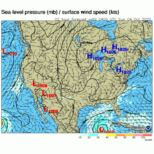
As expected, strong winds associated with TS Gamma are keeping most birds grounded. The stationary frontal boundary is currently sitting over South Florida, draped from the Palm Beaches, southwest to the 10,000 Islands, and extending into the Gulf of Mexico. We expect migrants to sit it out, and take advantage of the drier forecast for Sunday. It’ll be a good time to refuel for the next leg of their journey. A drier patch of air is expected to move into the Atlantic metro-areas, bringing some high heat index numbers (don’t forget your sun protection) to the region. Some birds may take advantage of the dry night conditions, and fly short distances, but we think the bulk of birds will sit tight. Further up the state, Jacksonville radar was lit. Birds moving fast from NE->SW, eventually meeting the inclement weather. There is potential for a major stack up of migrants with these conditions aloft.

Birds that made it to South Florida before the migration pipeline was shutdown, are likely to be moving locally, looking for suitable foraging habitat. Hit those tried-and-true migrant traps that offer lots of native habitat. These habitats are first choice by migrants, as they offer places to rest and refuel. Depending on what type of migrants you are in search of, you’ll need to find the food and the habitat to locate the birds. If you are in search of warblers, tanagers, orioles, thrushes and other neotropical migrants, then keep an eye out for fruiting figs or ficus trees. If you are in extreme South Florida—Gumbo Limbo, Pigeon Plum and Seagrape are all trees that offer a great fruit source for these migrants. You’ll want to pay attention to fruiting shrubs and vines too, plants such as American beautyberry, Marlberry, Virginia Creeper, Wax Myrtle, Florida Myrsine, Wild Coffee and Florida Trema all provide vital fruit in the fall.

Fall migration isn’t all about the colorful transoceanic travelers, there are also some globetrotting shorebirds and seabirds making their way south too. To find these migrants you’ll need to find places along the coast that offer a place to rest (most importantly) secondly, the birds will need to eat, so think of a beach that doesn’t get too much foot traffic and offers dunes and/or does not rake the shoreline. Shorebirds will also utilize flooded fields, often in agricultural areas. These places will certainly be devoid of sunbathers, but are hit or miss for migrating shorebirds, beaches are much more reliable.

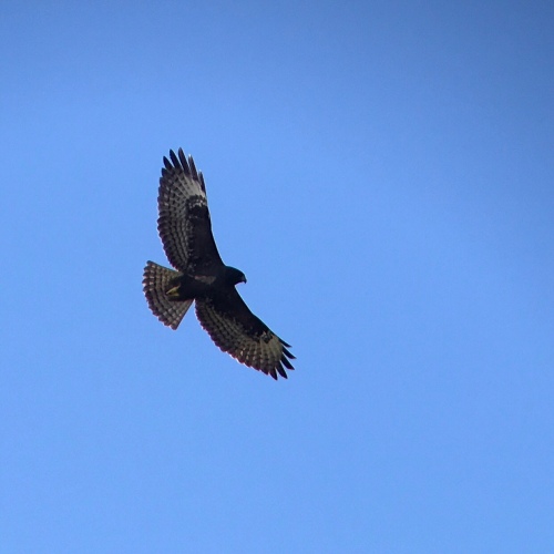
Raptors/birds of prey, will also be on the way south. Finding these birds will require a bit of patience for the beginner hawkwatcher, but don’t let it discourage you, these birds are amazing to watch in action. Migratory raptors can often be way up in the sky, nothing but a spec, but nonetheless, they are there. You’ll need to learn what to look for in order to find these birds, or you can visit a hawkwatch site and learn from the pros. The Florida Keys Hawkwatch at Curry Hammock State Park is the perfect place to learn. But visiting one of these monitoring sites is not necessary to enjoy raptor migration, one can do this right from home. Best days to locate these amazing creatures are days with North or Northeast winds, but any sunny day from late September to late October can yield some great birds. Keep your eyes on the sky, looking for any small objects that are circling or dive-bombing other birds, these are often raptors. Vultures! Can’t say it enough, look for vultures, because you’ll often find raptors flying with them, and they are easier to spot than smaller raptors. Our favorite thing about hawkwatching is seeing visible migration.

Be safe and have fun watching the birds fly by!

Nature is Awesome

Angel & Mariel

Posted by: NatureIsAwesome | October 3, 2020 @ 5:36 pm

Wet with a side of Birdy

Hey migration & birding peeps,

It’s been quite a while since we post on the blog, but we’ve been seeing such a great fall migration in South Florida, that we couldn’t just let it pass us by without covering the action from a meteorological & NEXRAD point of view.

We’ll cut straight to the chase, it’s going to be a wet weekend in South Florida, but birds could also be dripping from trees. A combination of factors are leading up to a stage play we’ve seen before, and if everyone shows up to the stage, we’ll remember the start to October 2020 for a great migration.

Earlier this week a frontal boundary made its way south into the state, temporarily clearing South Florida, and bringing a few nice birds along with it. Down this far south, weak cold fronts often find their way back north, and this front is no different. As the front reversed its path, it dragged some real wet weather along with it. As a result, diversity in migrants encountered by birders, also seems to have picked up a bit in South Florida towards the end of the work week. But the bulk of migrants continue to be held up, awaiting favorable winds north of the region.

Don’t worry though, a second frontal boundary is currently sliding south, causing a shift in winds, and triggering a wave of migrants to head south into Florida. The situation isn’t all that simple though, birds are headed south, but that pesky retreating frontal boundary has crept back into southern Florida. To add some spice to the pot, Tropical Storm Gamma has developed into quite the tropical system and is influencing the entire western Caribbean zone, bringing thick cloud cover and deep tropical moisture into Southern Florida, the Florida Straits and the Gulf of Mexico (setting up a block for migrants). Low-level winds are out of the NE as we write this interp, but will be shifting out of the east as TS Gamma moves towards the Yucatán Peninsula of Mexico. At higher levels, steering winds are out of the south/southwest, creating a favorable environment for widespread rain over Southern Florida, and also slows movement of storms, which could add to flash flooding concerns.

Migrants seem to like the wave they are currently ridding, and are flying south, but how far south will they likely travel? Winds will be shifting out of the east by the end of the weekend, pushing migrants west towards the interior portions of the state, and costal Western Florida.

Birds that are migrating down the western coast, could be pushed out over the Gulf of Mexico, and will need to reorient during daylight hours, hitting coastal migrant traps in late morning and afternoon hours. Conditions in the Gulf are not conducive for migration.

Birds that are traveling along the east coast, will encounter the wind shift and deteriorating flight conditions. We expect these birds to halt migration once the reach the inclement weather that is developing over South Florida. Radar data from Friday/Sat shows a nice stream of migrants flying along the east coast and over the Atlantic. These birds will have to put down as they encounter inclement weather. Migrant traps from the Space Coast region to the Palm Beaches will likely be the best place to find these birds. As the day continues, birds can continue their migration south, and often do as they forage, but will eventually “stack up” in Southern Florida (Palm Beach, Broward, Miami-Dade, Monroe, Lee & Collier Counties) as they await favorable migration conditions.

The soggy weather is likely to slow migrants’ progress, but the thick cloud cover that is forming will halt their migration. Often rain will drop some migrants that choose to not fly into wet weather, but low visibility (thick cloud cover, smoke, sand storm etc.,) will halt migration all together, creating fallout conditions. As conditions worsen over the Gulf of Mexico, the Florida Straits and Cuba, birds will be waiting out better weather ahead, before taking the over water migration.

Lookout, a great week of birding could be ahead! Thanks for taking the time to read our take on current meteorological happenings, and how they may affect neotropical bird migration in Southern Florida this weekend, and into next week. We hope to jump back on the saddle, and post more regularly. As always, these interpretations are only as good as the help we receive from the birding community. What you encounter on your bird walk is important to us, it helps us understand what we are interpreting, and if we are reading the radar and weather correctly. Thanks in advance friends!

Nature is Awesome

Angel & Mariel

Posted by: NatureIsAwesome | May 11, 2015 @ 12:37 am

Biggest Week Edition

Hey all,

We are up at the Biggest Week in American Birding this year! So far it has been a magical experience for these two migration junkies 🙂 It is a total change of pace for us, both in the way we look at migration and the shear number of birds.

When predicting bird movements via radar and weather forecast model data over Florida, we pay close attention to migration over the Gulf of Mexico and the Florida Straits. Here in Ohio we have to look at migration a bit differently. Birds are first moving over land and then heading out over the water, the total opposite of what is happening in Florida. Thus, velocity radar data becomes instrumental in our interpretations of images for this region. This data gives us information about what direction birds are traveling and at what speeds. An important thing to know when attempting to interpret and predict bird movements.

Rain is falling as we type over Curtis, Ohio, right on the lakeshore, just west of Magee Marsh and Ottawa NWR. Birds are on the move overhead too, which begs the question…will they land along the lakeshore? We can only wait and see 🙂

Below you will find a few images with some interpretation about what the data is telling us.

20150511-000018.jpg

Notice how velocity is increasing over Lake Erie. Birds are lifting off and picking up elevation before reaching the lakeshore. Once over the lake, they have already climbed to an optimal cruising altitude, and as a result are moving faster and more efficiently. This helps migrants cross this large body of water, especially with a tailwind.

20150510-235142.jpg
Current weather map shows us that a front is headed east while a stalled front is lingering. The stalled front should begin a shift to the east as the cold front moves in over the following days. Birds should be on the wing until the wet part of this front moves over the Great Lakes region.

20150510-235149.jpg
Look at those wicked awesome winds! Birds have a tailwind to carry them north and northeast from the Gulf of Mexico all the way north to the Great Lakes and Northeast region.

20150510-235251.jpg
Satellite imagery records lots of cloud cover just west of Ohio. This cloud cover will continue to move east as the cold front moves into the area. Birds can’t fly into thick cloud cover and fog, well they can, but are smart enough to drop down before being caught out over Lake Erie with less than optimal winds and weather conditions.

Over the coming days we should expect new arrivals at Magee Marsh and other hotspots in the area. Birds are on the move ahead of the front and will eventually meet up with a wind shift and precipitation courtesy of the front. We will try to post again tomorrow so that we can continue to monitor the weather as well as what migrants are doing. Stay dry folks!

Nature is Awesome
Angel & Mariel

Posted by: NatureIsAwesome | April 26, 2015 @ 9:04 am

West Winds Y’all

NOAA Current Weather Map

NOAA Current Weather Map

Hey all,

Hope you all are having a wonderful day and enjoying a few migrants too! Winds in the upper levels and surface levels are coming out of the west which pushes birds towards the eastern coast of the state. Birds had good flying weather last night and as a result, many flew right on past migrant traps. Best chances of concentrations will be in areas that had rainfall overnight.

Surface Level Winds

Surface Level Winds

Winds @ 3,000ft

Winds @ 3,000ft

Key West radar shows another moderate flight over the Florida Straits. With no real reason for birds to drop over the Keys, we only expect a trickle of migrants at tried-and-true migrant traps. The upper keys look best for birding from our perspective. Look out for migrants at natural areas and migrant traps along the chain of keys.

Miami radar recorded many birds headed for the metropolitan Miami area this morning. Moderate movements of migrants were headed up the coast with some dropping in on the coast. West winds are a South Florida birders best friend. These conditions often carry birds over the southeast coast and puts them down early morning at migrant traps and coastal natural areas. Places such as Elaine Gordon Enchanted Forest & Arch Creek Park, Greynold’s Park, Pinetree Park, Bill Baggs Cape Florida SP, Matheson Hammock Park, Chapman Field, Deering Estate and other tried-and-true migrant hotspots should see some turnover today. Inland locations like AD Barnes Park & Castellow Hammock county parks have the chance of picking up new arrives as well. Looking west to the Everglades National Park, look out for migrants that decided to put down before flying over to the east coast. Stops along main park road such as the Long Pine Key area, Hidden Lake, Mahogany Hammock and the Flamingo area of the park should be seeing new arrivals today as well. Get out there birding and let us know what you are seeing!

Moving into Broward and Palm Beach County, new arrivals will likely be on tap. Coastal migrant traps such as Anne Kolb Nature Center, Evergreen Cemetery, Hugh Taylor Birch State Park, Spanish River and Juno Dunes/Jupiter Ridge Natural Areas should be your best bet for these areas.

Further up the state one can expect a trickle of migrants, nothing spectacular, but migration should be noticeable. More birds on the east coast today than the west coast, but places like Fort DeSoto, Green Key, St. Marks NWR and other known migrant hotspots always see some turnover. The Merritt Island area as well as coastal hotspots up the east coast could be seeing new faces on the ground today. The northeast region received some rain last night, in these areas one could expect to see some grounded birds. Get out to your local natural areas and see if birds did indeed make a pit-stop overnight.

Enjoy the migration season y’all!

Frames are every 1/2 hour. Click on the thumbnail to view the full-sized animation.

Base Reflectivity image from Miami, FL Base Velocity image from Miami, FL Base Reflectivity image from Key West, FL Base Velocity image from Key West, FL

Nature is Awesome
Angel & Mariel

Posted by: NatureIsAwesome | April 24, 2015 @ 11:22 am

Clear Skies and Slow Birding

Hi all,

We will post interpretations of the radar as soon as we can. We are currently at a birding and photo festival and have not had solid internet connection. We took a quick look at the Miami and Key West radars and noted some moderate movements, mostly heading from south –> north. With clear skies overhead, birds are flying right past most of our migrant traps. We only expect a trickle of migrants today with the best spots being tried-and-true migrant traps.

We will try to update this a bit later today. Hope you all have a wonderful day!

Frames are every 1/2 hour. Click on the thumbnail to view the full-sized animation.

Base Reflectivity image from Miami, FL Base Velocity image from Miami, FL Base Reflectivity image from Key West, FL Base Velocity image from Key West, FL

Nature is Awesome
Angel & Mariel

Posted by: NatureIsAwesome | April 22, 2015 @ 9:44 am

Happy Earth Day!

20150422-120356.jpg
Hi all,

We hope you are all enjoying the increase in migrant numbers and diversity! The last few days have been phenomenal for birders across much of the state. This is all due to a slow moving cold front which brought us loads of rain and westerly winds. Conditions as such aren’t a birds best friend, but a birders dream, that’s for sure.

20150422-120624.jpg
The air is clearing and these birds are likely going to take flight starting tonight. It’s hard to tell how many birds will leave and how many will stick around. This all depends on when they arrived and how much food they have found. Another factor will be the winds. If winds aren’t optimal, migrants may stay put or move short distances in hopes of finding better habitat. West winds aloft persist, while weak, variable winds can be felt on the ground. Birds may stick around for a better night to fly, so they may be around tomorrow!

*Just uploaded* We have not been able to download the radar today, but we did watch it overnight and early this morning. Many migrants were out over the FL Straits last night. Winds and the unsettled atmosphere over the southern Gulf sparked off large areas of precipitation, likely put birds down in the Dry Tortugas, the FL Keys and southern Miami-Dade which covers the national parks and most the migrant traps.

Look out for birds if it was raining over your area overnight and this morning. You should see a noticeable difference from the days past.

Here are a few satellites images showing that the the majority of the clouds have moved east of the state, but still some moisture lingers over the southern Gulf of Mexico.

20150422-095653.jpg

20150422-095700.jpg

Frames are every 1/2 hour. Click on the thumbnail to view the full-sized animation.

Base Reflectivity image from Miami, FL Base Velocity image from Miami, FL Base Reflectivity image from Key West, FL Base Velocity image from Key West, FL

Nature is Awesome
Angel & Mariel

Posted by: NatureIsAwesome | April 20, 2015 @ 7:19 am

Gulf Passage Drama

20150420-073454.jpg Hi all, A look at radar images this morning proves some birds made the flight north overnight. A looming area of instability courtesy of a slow moving cold front is over the Gulf of Mexico. Stormy weather continues to brew and should be making it really hard for migrants that are attempting a Gulf passage this morning. Migrant traps along the west coast of Florida and the panhandle may have the best chances of seeing a concentration of migrants today and tomorrow. Take a look at satellite images of the Gulf and see why we think birds are trapped and may vector birds towards Florida’s west coast. From the SW coast to St. George Island, today is looking like a good day for the birder.

20150420-073317.jpg

20150420-073421.jpg We also noticed a roost ring just west of Ft. Lauderdale this morning. As birds are flying out for their morning forage, radar records the group of birds flying out of the marsh. Check out these images.

20150420-073430.jpg

20150420-073437.jpg

20150420-073442.jpg Overall, winds have shifted out of the south (SSW aloft) and should have birds on the wing over the state.

20150420-073500.jpg Look out for new arrivals at your favorite migrant trap today. If you have time to travel, keep an eye out for reports at classic migrant traps such as Fort DeSoto, St. George Island, Sanibel Lighthouse, Key West and others. The Dry Tortugas may also be seeing some migrants today. Reports of migrants been slow out there this week. Let’s see what today brings!

Frames are every 1/2 hour. Click on the thumbnail to view the full-sized animation. Base Reflectivity image from Miami, FL Base Velocity image from Miami, FL Base Reflectivity image from Key West, FL Base Velocity image from Key West, FL

Nature is Awesome
Angel & Mariel

Posted by: NatureIsAwesome | April 19, 2015 @ 4:33 pm

Spring Mix

Well the spring cycle continues to be working for the birds because we aren’t seeing them 🙂 Some birds are trickling in here and there, but nothing huge.

Unstable conditions persist over the Gulf, as a result we are seeing large thunderstorms making their way towards the coast. This could be making it hard for birds to travel where they want to go, and may put them down along the first stretch of land they find. Currently a strong squall line is moving east of Tallahassee, check out the radar image.

20150419-161952.jpg
This system is forecast to continue to move across FL and may affect folks all the way south to Miami or even the FL Keys. Keep an eye out for localized concentration of migrants, these pockets of great birding can be just around the corner. Enjoy another Sunday of birding 🙂

Frames are every 1/2 hour. Click on the thumbnail to view the full-sized animation.

Base Reflectivity image from Miami, FL Base Velocity image from Miami, FL Base Reflectivity image from Key West, FL Base Velocity image from Key West, FL

Nature is Awesome
Angel & Mariel

Posted by: NatureIsAwesome | April 18, 2015 @ 3:56 pm

Gulf Bound Migration

Looks like another Gulf bound migration for the birds. Winds aloft likely carried birds out over the Gulf of Mexico(GOM), if this is the case, birds have it hard. Storms have been brewing in the GOM and coastal locations along their arrival points, essentially blocking their passage. If migrants did indeed fly last night, they will be looking for a landing spot pronto. Check out these satellite images of the GOM, here you can see stormy weather which is moving W->E along the coast. One image is the visible sat the other is a water vapor sat image.

20150418-154750.jpg

20150418-154854.jpg

This system will continue its move to the east where it becomes a serious threat to birds migrating. If timing works out right, tomorrow may be a really good to go birding. Depends on how long this system takes to clear out. All we can do is wait and see what happens.

20150418-155022.jpg

Radar loops from last night into midday today were rather slow. Key West radar showed some migration, birds moving SSE->NNW. Miami radar had some more action, but that action flew right over :/ Velocity radar shows us that birds were moving S->N over this radar location. This should have out migrants out north of Lake O’ by morning which bodes well for inland spots in the Central FL. Hope to hear from readers in that area, post your findings 🙂

Frames are every 1/2 hour. Click on the thumbnail to view the full-sized animation.

Base Reflectivity image from Miami, FL Base Velocity image from Miami, FL Base Reflectivity image from Key West, FL Base Velocity image from Key West, FL

Nature is Awesome
Angel & Mariel

Posted by: NatureIsAwesome | April 17, 2015 @ 8:34 am

Moderate Movement SE–>NW

Migrants continue to have great travel weather. What works for the birds doesn’t necessarily work for the birders. The spring weather pattern in Florida usually keeps southeast winds on tap, just what a migrant coming from the West Indies wants. This weather pattern bodes well for long distance travel assisted by tailwinds and clear skies. As migrants continue to take the SE->NW path they will continue to shoot over the SW portions of the state and out over the Gulf of Mexico, nearly cutting their trip north in half. What that means for the birders is simple, go birding and take what you can get while you wait for better birding conditions. So if you are out birding and have not seen many migrants, this is why! Have patience for the weather pattern is changing up.

A look at the Key West radar paints the picture of a classic spring migratory movement. Birds depart from Cuba and points farther south or east and ride the super highway to the Gulf coast. Birds want to get there quick, and southeast winds are getting them there.

There is a silver lining to the cloud…there seems to be a temporary break in the forcefield, upper level winds are forecast to switch overnight. Looks like winds will be shifting out of the SW and eventually out of the west in the coming day. If birds depart from the Yucatan Pennisula and the West Indies tonight, they should be vectored towards the Sunshine State! These winds may only affect the northern half of the state, but could bring in some birds to Fort DeSoto and other west coast migrant traps. Get out birding tomorrow morning and let us know what you find. We would love to get some reports from our “boots on the ground”, simply leave a comment here or comment on Facebook. Shoot us a tweet with the info if you’re into Twitter…tweet tweet! Enjoy the weekend 🙂

Frames are every 1/2 hour. Click on the thumbnail to view the full-sized animation.

Base Reflectivity image from Miami, FL Base Velocity image from Miami, FL Base Reflectivity image from Key West, FL Base Velocity image from Key West, FL

Older Posts »

Categories